Beach Drive & Climbing Course
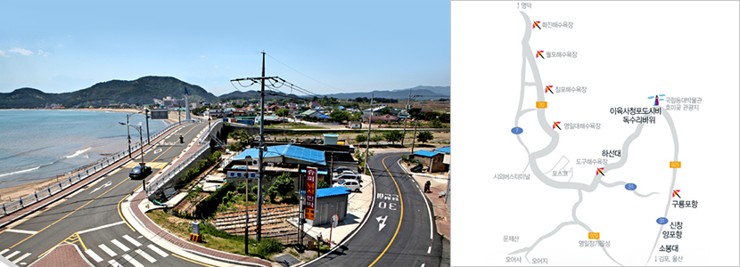
Seashore drive course
- It is the best drive course where you can feel the smell of the sea, enjoy the cultural assets and artifacts of Pohang, see the sea and feel the nature by feeling the sea scent, lined with famous beaches everywhere along the 204km coastline.
-
- CourseSobong-dae → Yi-Yuksa "Green Grapes" Poem Stele→ Ka-Kurigye Eagle Rock → Haseondae
-
-
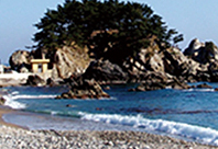
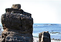
- ① Sobong-dae
- This is the island where the small Beacon Fire Station was located, and it served as the outpost of the Bokgil Beacon Fire Station. It has beautiful scenery and abundant fish species. There are many fishermen from all over the country and main target fish species are spotty belly greenling, rock cod, flounder, and Japanese halfbeak.
-
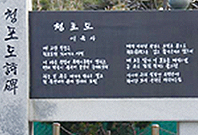
- ② Yi-Yuksa "Green Grapes" Poem Stele
- Through this poem, Yi-Yuksa sang a wish for a rich and peaceful life.
The fresh sensation of the material, green grapes and the bright color images harmonize with each other to give beauty and generality to the whole work. Especially, the oppressed reality under colonialism is confronted with the reality that the poet dreams of, and contains the will to overcome it. The size is 3m in width, 1.2m in height, and 2.5m in height. The inscription and the poetry poem are carved, and the design of the sculpted sculpture was composed by Professor Hong Seongmun of Yeungnam University, epitaph was by Sonchun Ik of the children's literature, and writings by the calligrapher Jeong Hyeong-sik.
-
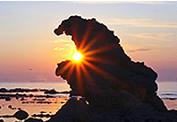
- ③ Ka-Kurigye Eagle Rock
- This area is called "Ka-Kurigye" through the fact that when the wind and waves are severe, the fish (clupea) gets pulled out many times and the name is also derived from the dialect word "ka-kuri" meaing "hook". The eagle rock is a name given by the people because the shape of the stone carved by the weathering process for a long time resembled an eagle's beak. The sunset that goes from the end of Homigot to the West is a sunlight that glows over the Daeheung Mountain and clearly reflects the mountains stratum and the city area, especially the Young-il Port POSCO chimney, which is a superb image reminiscent of oriental painting. Therefore many photographers, including media and broadcasters come by to Ka-Kurigye Eagle Rock.
-
- ④ Haseondae
- It is said to be the Haseondae because there is a saying that the priestess came down to a small rock in Hanmiki, the name of Hwangmokpo, which is the boundary point between Yip-Amri and Masanri in the Haseondae East Coast. In the past, the Dragon King of the East Sea invited many priestesses every seventh day of the seventh month of the lunar calendar to dance and sing, and one day he wanted to be marry one of the priestresses after getting attracted by this good-looking, beautiful priestess, but the Great Jade Emperor did not allow it. However, in order to make up for the Great Jade Emperor, he worked hard for human beings, such as calming the sea and removing the typhoon, and that resulted in the Great Jade Emperor to let the marriage take place. It is told that the Dragon King and the priestess came down here to spend quality time together very often.
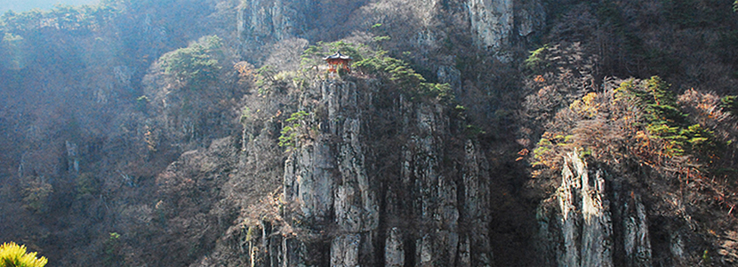
Mt. Naeyeon Hiking Course
- Mt. Naeyeonsan is at the south of the Taebaek Mountains facing the East Sea . Since it is not a steep mountain even children can easily climb the mountain. While enjoying the charm of Bogyeongsa Temple which has a long history, and the beautiful waterfalls and the thick forest you will find yourself at the summit of the mountain.
-
- AddressJoongsan-ri, Songra-myeon, Pohang, Gyeongbuk
-
-
- ① Mt. Naeyeon Area Hyangrobong Mt. / 930m
- Course 1 : Parking lot → Bogyeongsa Saryung Hill → Munsubong → Samjibong → Madangmigi → Hyangro Bridge Crossroads → Hyangro Mt.
- Course 2 : Parking Lot → Bogyeongsa → Munsuam Crossroads → Sangseng Falls → Bohyunam → Gwaneum Falls → Eun Falls → Challpi Entrance → Shimyung-ri → Hyangro Mt.
- Course 3 : Ha-ok Hyangro Bridge → Junungsun Crossroads → Hyangro Mt.
- Course 4 : Samejae → Maebong → Flower Garden Crossroads → Hyangro Mt.
- Course 5 : Samejae → Three-way Intersection → Sun-rock → Shimyung-ri → Hyangro Mt.
-
- ② Mt. Chunryeong Area Woochuck Mt. / 775m
- Course 1 : Parking Lot → Bokyung 2 Bridge → Triangulation Station → Hanuije Crossroads → Umji Rally Crossroads → Woochuck Mt.
- Course 2 : Parking Lot → Bokyung 3 Bridge → Heliport → Umji Bat-dung Crossroads→ Woochuck Mt.
- Course 3 : Samejae → Satgat Mt. → Wesolbegi → 683 Bong → Woochuck Mt.
- Course 4 : Samejae → Three-way Intersection → Woochuck Mt.
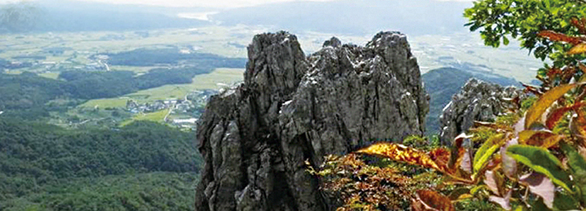
Bihak Mountain
- The shape of the mountain is a crane ascending the sky after brooding, named as Bihak Mountain. There is a peak at the top of the mountain, and a small mountain-shaped bumpy peak at the middle of the eastern side and this peak is called the Dung-janhyul and the seedlings are said to be well if you write a tomb at Dung-janhyul.
In particular, the legend has been written that if you write tombs in Dung-janhyul, you need to get further away from it, as being close to it will make you fall but being far away will lead you to prosperity, and if you write a tomb in the Bihak Mountain, there is also a legend that you will face a drought. Thus, there were also occasions where the village livers would unite their feelings and pray for rain, or there were also occasional bad happenings as near village-livers sometimes dug the tombs. Nowadays, many hikers are attracted by the lush trees, beautiful scenery and clear water, from the Bupgwangsa to the top of Bihak Mountain.
-
- AddressTapjeong-ri, Gibuk-myeon, Mihyeon-ri, Gigye-myeon, Sangeup-ri, Singwang-myeon, Buk-gu, Pohang-si, Gyeongsangbuk-do, South Korea
- NumberBupgwangsa Jongmuso +82-54-243-0178
-
-
- ① Hiking trail
- Course 1 : Bupgwangsa → Valley → Tomb 1 → Observatory → Fog Rock → Top
- Course 2 : Bupgwangsa → Valley → Tomb 4 → Anbu → Top
- Course 3 : Bupgwangsa Parking Lot → Mujedung → Laid Rock → Anbu → Top
- Course 4 : Sangeup-ri → Rock → O-bong → Anbu → Top
- Course 5 : 2 Tapjeong-ri → Dam → Valley → Tomb 2 → Anbu → Duryukbong → Anbu → Top
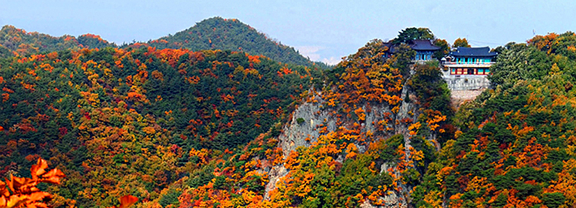
Eunje Mountain
- It is said that the Eunje Mountain was named after the Grand Master Wonhyo named the Wonhyo Rock and Jajang Rock and was seeking for asceticism, as he moved between the two rocks through the Cloud Bridge since it was hard to move between the two rocks due to the fact that they are on two different cliffs. It is also being said that it was named after Eunje Mountain as there lies the Sungmodan for the second Namhae Queen Eunje's wife from Silla. In the past, it is said that ancient monks such as Jajang, Wonhyo, and Hyeong-gong used to seek for enlightenment through asceticism in this mountain.
In particular, the legend has been written that if you write tombs in Dung-janhyul, you need to get further away from it, as being close to it will make you fall but being far away will lead you to prosperity, and if you write a tomb in the Bihak Mountain, there is also a legend that you will face a drought. Thus, there were also occasions where the village livers would unite their feelings and pray for rain, or there were also occasional bad happenings as near village-livers sometimes dug the tombs. Nowadays, many hikers are attracted by the lush trees, beautiful scenery and clear water, from the Bupgwangsa to the top of Bihak Mountain.
-
- AddressSanyeo-ri, Daesong-myeon, Hangsa-ri, Ocheon-eup, Nam-gu, Pohang-si, Gyeongsangbuk-do, South Korea
- EventEvery February, Sungmodan runs a religious ritual for the mountain also with the Youngil Mountain Club
-
-
- ① Hiking trail
- Course 1:O-Eosa → Jajangam → Sanyeo Farm → Eunje Mountain top → Daewangam (Takes an hour and a half)
- Course 2:Youngilman Sauna → Heliport → Pylon → Eunje Mountain top → Daewangam (Takes an hour and a half)
- Course 3:Hongye-ri → Yongamsa → Hongye Falls → Sigyeongjeneungseon Crossroads → Eunje Mountain → Daewangam (Takes 4 hours)
- Course 4:O-Eosa → Jajangam → Eunje Mountain top → Shiryubong → Imdo → Wonhyoam → O-Eosa (Takes 5 hours)

